16.060 Single Lot Development.
A. Purpose. To ensure that the development of parcels subject to the requirements of this Chapter is consistent with the General Plan goals and policies related to hillside development, and is not visually prominent when viewed from a community “viewing platform”.
B. Applicability. Section 16.060 applies to New Development, as defined by this chapter, on any parcel located in the South Hills and West Hills, as defined by this Chapter.
C. Site Plan and Architectural Review. Planning Commission approval is required for new development in the South Hills and West Hills.
D. Development Standards. Any parcel subject to this Chapter is also subject to the requirements of the zoning district in which the parcel is located. Where the requirements of the underlying zoning district conflict with the requirements of this chapter, the requirements of this Chapter shall control.
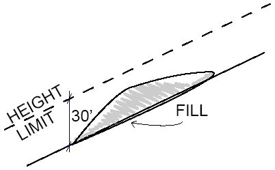
1. Building Height. 30 vertical feet from grade to the uppermost point of the roof as calculated below (see Figures 16.3, 16.4 and 16.5). No point of any structure shall be more than 30’ above the grade directly beneath that point.
Figure 16.3 Height Limit when Graded for Foundation Only
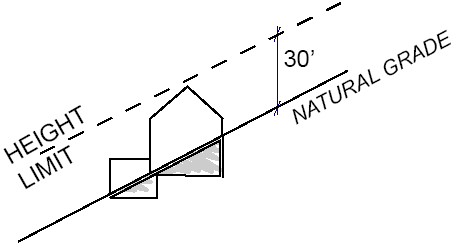
Figure 16.4 Height Limit when Graded for Flat Pad
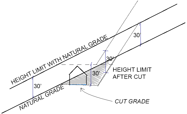
Figure 16.5 Height Limit when Adding Fill
2. Setbacks. As prescribed by the underlying zoning district in Tables 4.6 through 4.9.
E. Exception to Required Setback. An exception to the setback required by the underlying zoning district may be provided for as follows:
1. Primary Structure. A primary structure may encroach into a required setback for a distance of not more than one-half of the required setback, subject to approval by the Planning Commission, if it can be found that the decrease minimizes the impact of hillside development and grading and is consistent with the guidelines contained in this chapter. If such a reduction is granted, a compensating increase in setback is required in the opposing setback. For example, a five-foot (5’) reduction in a front setback would increase the rear setback by five feet (5’).
2. Required Covered Parking. Required covered parking may encroach into a required front and/or side yard setback if the decrease minimizes the impact of hillside development and grading and is consistent with the guidelines contained in this chapter.
Findings Required.When the Planning Commission approves a reduction in the required setback, findings to support the granting of the exception shall be provided.
F. Additional Setback Required. In order to protect significant natural resources or to reduce visual prominence of a proposed development, the Planning Commission may require building setback(s) that exceed(s) the required setback of the underlying zoning district.
G. Exception to Retaining Wall Height (Section 13.050). For projects subject to Section 16.060, a maximum exposed retaining wall height of five feet (5’) may be permitted with Planning Commission approval.
H. Site Design. The following site design guidelines shall be taken into consideration and incorporated into the design of a hillside lot whenever possible. Conformance with these guidelines will be determined by the Planning Commission.
1. Development patterns that form visually protruding or steeply cut slopes for roads or lots should be avoided.
2. Building pads, including spaces leveled for foundations and the grading for driveways and yards, should be as small as possible.
3. Building construction and related site grading should not significantly disturb any ephemeral or perennial watercourse on the site.
4. Buildings should be located to take advantage of existing vegetation for screening.
I. Architectural Design. The following architectural design guidelines shall be taken into consideration and incorporated into the design of a hillside lot whenever possible. Conformance with these guidelines will be determined by Planning Commission as part of project review.
1. Design buildings to conform to the natural topography and hillside setting of the site; to follow the contours of the site; and to blend with the existing terrain in order to reduce bulk and mass.
2. Scale structures to fit the surroundings, and not visually dominate the landscape. The apparent size of exterior wall surfaces visible from off site may be minimized through the use of single story elements, split level foundations, varying setbacks and structure heights, and landscaping, all designed to break up massive forms.
3. Design buildings to minimize bulk, mass and volume.
4. Bulk and Mass. Bulk and mass should be minimized when developing a hillside parcel. The following methods may be used to minimize the bulk and mass of a building.
a. Keep building forms simple (see Figures 16.1 and 16.2).
b. Avoid architectural styles that are inherently viewed as massive and bulky.
c. Utilize grading cuts, rather than fills, to create building pads.
d. Excavate or use below-grade rooms to reduce effective bulk. The visual area of the building can be minimized through a combined use of grading and landscaping techniques. Earth sheltered buildings and “living roofs” are encouraged.
e. Exposed understory stem walls should not exceed 5’ and should be finished with visually recessive, earth-toned materials.
f. Step the building foundation and roofs with the natural slope (see Figures 16.1 and 16.2).
g. Use horizontal and vertical building components to reduce bulk.
h. Avoid two story wall planes.
i. Step back the second story so the difference in wall planes is visible from a distance.
j. Vary elevations, such as stepping back second stories, to conform with topography.
k. Avoid overhanging decks, large staircases, and patios formed by retaining walls that make buildings appear more massive (see Figure 16.3).
l. Avoid use of solid wall railings that add to the mass of the design.
m. Create light and shadow by providing modest overhangs, projections, alcoves, and plane offsets.
n. Use a combination of siding materials and articulate walls to reduce expansive, continuous planes.
o. Use vaulted ceilings rather than high walls and ceilings to attics above to achieve a feeling of volume.
5. Colors and Materials. The following methods may be used to reduce the visibility of hillside development:
a. Use subdued and unobtrusive exterior finish materials and colors for all structures.
b. Minimize the use of reflective material.
c. Earth tones and colors that occur naturally in the Petaluma hills are encouraged.
d. Structures should not call undue attention to themselves when viewed from a public vantage point.
6. Roofs.
a. Break roof forms and rooflines into smaller building components to reflect the irregular forms of surrounding natural features (see Figures 16.1 and 16.2).
b. Generally orient the slope of the main roof in the same direction as the natural slope of the terrain (see Figures 16.1 and 16.2).
c. Avoid large gable ends on downhill elevations.
d. Light colored and reflective roofing materials are discouraged.
J. Process. As prescribed by Section 24.050 (Site Plan and Architectural Review).
K. Findings. In addition to the considerations for review identified in Section 24.050(E) (Standards for Review of Applications), the following findings, where applicable, are also required:
1. The project meets or exceeds the objectives, standards, and guidelines of the Hillside Ordinance.
2. The design, scale, massing, height and siting of development is compatible and complementary with the character and scale of the surrounding, developed neighborhood.
3. The design and site layout of the hillside project is respective of and protects the natural environment to the maximum extent feasible.
4. Site grading has been designed to be as minimal as possible to achieve sensitive hillside design, minimize tree removal and provide safe site access and required parking.
L. Submittal Documents. In addition to the submittal requirements identified on the Development Permit Application Submittal Requirements Matrix the following shall be provided as indicated:
1. Opportunities and Constraints Map/Site Analysis is required for all projects.
2. Visual Analysis as required at the discretion of Planning staff or the decision making authority.
3. Arborist Report and/or Tree Preservation and Protection Plan as required by Section 17.055. (Ord. 2811 § 4, 2022.)