16.050 General Provisions.
A. Purpose. The purpose of this Section is to provide design direction for hillside projects in order to create development that is compatible with and appropriate for the hillside setting, and is consistent with the objectives of this chapter and the goals and policies of the General Plan.
B. Applicability. Section 16.050 applies to new development as defined by this Chapter and the subdivision of property subject to the requirements of this Chapter. Section 16.060 provides specific requirements that apply to Single Lot Development. Section 16.070 provides specific requirements that apply to Hillside Subdivisions.
C. Opportunities and Constraints Map. An Opportunities and Constraints Map should be prepared prior to siting any proposed improvements (structures, roads, driveways, utilities, fencing, etc.). An opportunity and constraints map includes, but is not limited to, the location of landslides, drainage patterns, creeks, trees with a trunk diameter of 4" or more and their surrounding habitat, ridgelines, existing roads and/or trails, structures, areas with a slope of more than 30%, and property lines. The purpose of the Map is to assist in the following:
Identifying the site features that should be preserved and retained;
Determining the best location for the building(s);
Determining the location for the road and/or driveway;
Determining how best to site improvements to work with the natural topography and reduce grading; and
Determining the best use of retaining walls to reduce the amount of grading.
D. Visual Analysis. The purpose of the visual analysis is to simulate the impact of the proposed project within the context of its surroundings. When siting and designing the improvements for the project, consideration should be given to the potential visual impact of the project on community views of hillsides and ridgelines. In order to evaluate the potential impact of a project on community views, specific view platforms have been identified. When selecting a view platform(s) for the visual analysis, priority should be given to those platforms that provide the greatest community view of the project. Depending on the location and visibility of the project, a visual analysis may need to be prepared from more than one view platform. A visual analysis includes site improvements (structures, roads, driveways, etc.) and site modifications (tree removal, grading, retaining walls, fences, etc.).
E. Site Design. The following should be considered in order to minimize grading, reduce the potential visual impact, and to maintain the existing features of the site.
1. Site buildings and other improvements (i.e., roads and driveways) to conform to topography and take advantage of existing site features (see Figures 16.1 and 16.2).
2. Limit building pads to the area immediately beneath buildings or driveways, or as required by the geotechnical report or Building Code.
3. Reduce the visual prominence of development as viewed from identified community “viewing platforms.”
4. Site buildings to allow adequate space for tree plantings or other screening.
5. Avoid fence lines that daylight ridgelines, are highly visible from a distance, and/or separate development parcels from open space (see Figure 16.3). Fences should be transparent (wire mesh, deer fencing, etc.). If chain link or wire mesh finer than 4" is used, it should be finished with a dark colored coating material.
Figure 16.1 Recommended
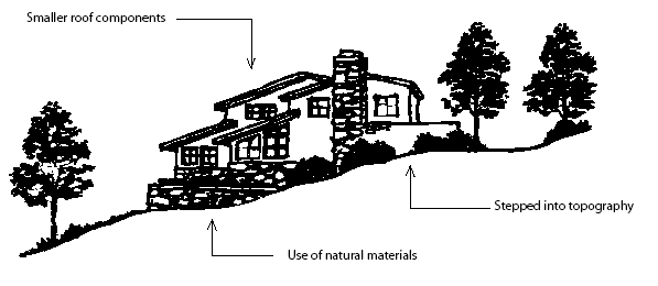
Figure 16.2 Recommended
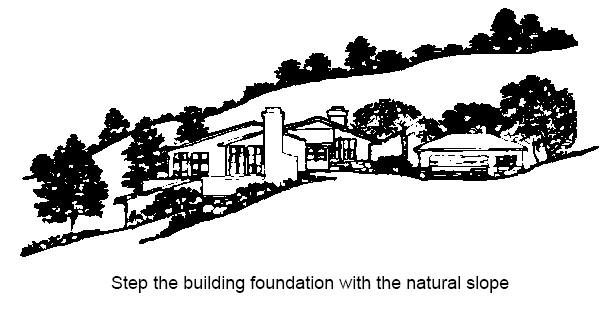
Figure 16.3 Not Recommended
F. Grading and Retaining Walls. The following should be considered in order to minimize grading and to preserve the natural topography of the site.
1. Design grading to conserve natural topographic features and appearances by minimizing the amount of cut and fill and by means of land form grading to blend graded slopes and benches with the natural topography; straight graded cut and fill slopes are discouraged.
2. Design grading to retain major natural topographic features (i.e., canyons, knolls, ridgelines, and prominent landmarks rock outcroppings, and drainage ways).
3. Discourage building pads created on fill (see Figure 16.5). Cut pads are preferred (see Figure 16.3).
4. Utilize grading to help set structures and roads into the hillside, not to create elevated pads (see Figures 16.1 and 16.2).
5. The limited use of retaining walls may be allowed when it can be demonstrated that their use will substantially reduce the amount of grading.
6. Retaining walls should not be used to create large, flat yard areas.
7. Retaining walls should blend with the natural topography, follow existing contours, and be curvilinear to the greatest extent possible.
8. Retaining walls should not be higher than five feet. Where an additional retained portion is necessary due to unusual or extreme conditions (e.g., lot configuration, steep slope, or road design), the use of multiple-terraced, lower retaining structures is preferred.
9. Terraced retaining walls should be separated by at least a three foot planting pocket and should include appropriate landscaping.
10. Retaining walls that are visible from a public street should have a veneer of natural stone, stained concrete, or earth toned textured surface to help blend the wall with the natural hillside environment and to promote a rural character.
G. Roads and Driveways.
1. Roads should be designed to minimize excessive cutting.
2. Driveway lengths should be minimized and common driveways should be planned for in subdivision and single lot site planning.
3. Roads should be pedestrian-friendly where feasible, with trails to open spaces at ridgetops, so long as the sidewalk or improvement does not create excessive grading or conflict with Fire Department or Public Works requirements.
H. Landscape Planting and Tree Preservation.
1. Compliance with Chapter 17 (Tree Preservation).
2. Submittal of an arborist’s report and/or tree preservation and protection plan as required by Section 17.055 (Project Arborist Requirements).
3. Provide landscape planting adjacent to retaining walls. Such planting should include a combination of non-invasive trees, shrubs, and vines to screen the wall.
4. Avoid the use of invasive species.
5. Utilize plant materials to screen structures, frame views, disguise building edges and understories, break up expansive walls, connect structures to the land and reduce the apparent bulk of structures.
6. Shade potentially reflective surfaces with tree canopies where appropriate, except when needed as solar access for rooftop solar panels
7. Revegetate cut and fill slopes.
8. Encourage the planting of water conserving and erosion control plant materials.