16.070 Hillside Subdivisions.
A. Purpose. To create appropriately sized, located, and configured parcels that can be developed in a manner consistent with this chapter and the General Plan goals and policies related to hillsides and ridgelines.
B. Applicability. Section 16.070 applies to any subdivision of property proposed for a parcel or group of parcels located in the South Hills and West Hills, as defined by this Chapter, and any parcel of land located within the City that has an average slope of 10% or greater as determined using the Average Slope Formula contained in Section 16.070 (C1).
C. Minimum Parcel Size. The minimum parcel size shall be determined by the underlying zoning district or as calculated by the slope density formula and/or table contained in Section 16.070(C2), whichever is greater.
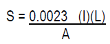
1. Average Slope Formula. The average slope of the parcel shall be computed on the natural slope of the site before grading, as calculated using the following formula:
|
I. | The contour interval measured in feet. |
|---|---|
|
L. | The sum of the length of all contour lines contained within a subject parcel measured in scale feet. |
|
A. | The area of the parcel in acres. |
|
S. | The average cross slope of a specific parcel of land expressed in percent as determined by the “Average Slope” formula. |
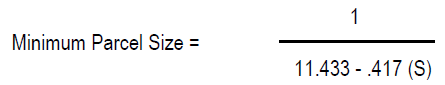
2. Slope Density Formula. The minimum parcel size shall be determined by the following formula, or the table below:
3. Above 25% slope, one additional acre or portion thereof per dwelling unit will be required for each additional 5% increase in slope.
4. Calculations of the average slope and the minimum parcel size shall be calculated by a registered civil engineer or a licensed land surveyor using the formulas provided in Section 16.070(C1 and C2).
5. Modifications to Minimum Parcel Size. In a residential Planned Unit District (PUD), the minimum parcel size may be flexible in order to respond to site conditions and to comply with General Plan goals and policies related to the clustering of development. The maximum number of dwelling units or lots shall remain as prescribed in Section 16.070(D).
D. Density. The maximum number of dwelling units or lots is calculated by dividing the size of the lot to be subdivided by the minimum parcel size required by Section 16.070 (C2). No project is guaranteed the maximum density. The actual density yield shall be determined by the decision making authority. When calculating density, any fraction shall be rounded down to the next whole unit. The density shall be consistent with the General Plan density range for the site and the density as calculated by this section.
E. Development Standards. Any parcel subject to this Chapter is also subject to the requirements of the zoning district in which the parcel is located. Where the requirements of the underlying zoning district conflict with the requirements of this chapter, the requirements of this chapter shall control.
1. Exception to Retaining Wall Height (Section 13.050). For projects subject to Section 16.070, a maximum exposed retaining wall height of 5 feet (5’) may be permitted with approval of the review authority.
F. Process. The process for the subdivision of land shall be as prescribed in the City’s Subdivision Ordinance (Municipal Code Title 20).
G. Submittal Documents. In addition to the submittal requirements identified on the Development Permit Application Submittal Requirements Matrix the following are required as part of an application for a subdivision of land:
1. Topographic Survey
2. Opportunities and Constraints Map/Site Analysis
3. Slope Analysis: at a minimum delineating areas with slopes of 0-10%, 10%-15%, 15%-30%, >30%
4. Soils Report
5. If Buildings are proposed with subdivision, include the following:
a. Architectural drawings
b. Visual analysis
c. Landscape planting plans for common areas, tree mitigations, cut/fill slope revegetation, and typical front yards
H. Appeal. As prescribed in the City Subdivision Ordinance (Municipal Code Title 20).